In the spring of 1942, the United States Army set itself a task that sounded like something out of a fever dream. Punch a road 1,700 miles long from a railhead in northern British Columbia all the way to Alaska, through country that had no road running through it at all. No highway, no gravel line, nothing you could drive from one end to the other. Just muskeg, black spruce, mountain passes, and rivers still frozen when the work started.
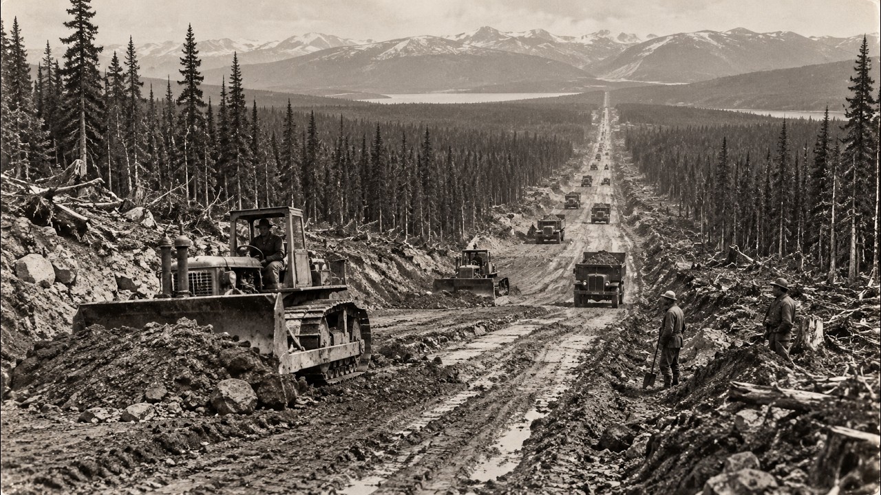
They gave themselves one building season. They finished the pioneer road in about eight months. The urgency made no sense without the war. For most of American history, Alaska was reached by boat.
There was no land connection worth the name. That was fine for a territory the rest of the country mostly wrote off as a frozen afterthought. It stopped being fine on December 7th, 1941. After Pearl Harbor, the entire Pacific coast of North America suddenly felt like a front line, and the sea route to Alaska looked like exactly what it was: a long thin lifeline that a submarine could cut.
Then, in June 1942, the fear stopped being theoretical. Japanese forces struck Dutch Harbor in the Aleutians and put troops ashore on two American islands, Attu and Kiska. It was the first enemy occupation of American soil in a very long time. American forces would not pry those islands back until 1943.
Washington decided it could not gamble the whole territory on ships staying safe. It needed a land route up the spine of the northwest, back from the coast, out of easy reach of anything at sea. The decision came down in February 1942. Build an overland military highway from Dawson Creek, British Columbia, up through the Yukon, all the way to Delta Junction, Alaska, where it could tie into the Richardson Highway, the one real road that already reached toward Fairbanks.
About 1,700 miles of it, and build it now. There was a second reason for that exact line on the map. Running up through the same wilderness was a string of airfields called the Northwest Staging Route, quietly built by the two countries to ferry warplanes north. Thousands of American aircraft were flown up that chain of fields, handed over to Soviet pilots in Alaska, and flown across to fight the Germans on the Eastern Front.
Those airfields were scattered across country with almost no way to reach them on the ground. The road was meant to do two jobs at once: it would be the safe overland lifeline to Alaska, and it would string those airfields together. The route was not chosen for the scenery. It was chosen to follow the planes.
The Army Corps of Engineers got the job, and the plan they came up with was the only one the ground would allow. They would not build the road neatly from one end to the other. They would leapfrog, cutting the route into sections and dropping regiments all along its length, some pushing north, some south. Roughly 11,000 soldiers went in, spread across seven engineer regiments.
Behind them came the civilians. Counting the 16,000 or so American and Canadian contract workers and the Public Roads Administration crews who came to turn the rough military track into something that would last, the total workforce climbed past 25,000 people with some 7,000 pieces of heavy equipment. The final bill came to around $138 million, making it the most expensive construction project the United States built during the entire war. The planning was thin.
In many places, nobody actually knew where the road should go because the country had never been properly mapped. Survey parties went out ahead of the machines on foot, by boat, and by little bush planes, scouting a line through the trees and swamp, maybe a few days in front of the bulldozers coming up behind them. The road was being designed and built almost in the same motion. Equipment came in by ship to the port of Valdez, some of it flown up to those staging route airfields and worked outward from there.
There was no supply chain waiting. They built the thing they needed while they were using it. The ground beat them first. The enemy on this project was never a man.
It was the land, and the land had two weapons no one in a warm office in Washington had fully understood. The first was muskeg, the northern bog, a deep soft mat of half-rotted moss and peat sitting on top of waterlogged ground. A bulldozer would start across a stretch that held a walking man just fine, and the machine would simply go down, sinking until the tracks disappeared and sometimes until the whole thing had to be dragged out by another dozer that was in danger of sinking too. The engineers fell back on the oldest trick in the book.
They cut down trees, thousands of them, and laid the trunks side by side straight across the bog like a raft, a corduroy road, and drove on top of that. It shifted and buckled and heaved under every truck, but it floated the traffic across ground that would otherwise have swallowed it whole. The second weapon was worse, because it turned the crew’s own work against them: permafrost. Under a lot of that terrain, the ground a foot or two down was permanently frozen, rock hard and holding.
What kept it frozen was the blanket of moss and brush and trees on the surface, shading it from the sun. The first thing a road crew does is strip that surface off to grade the roadbed. The moment they did, the sun got at the permafrost that had been sealed away for millennia, and it began to melt. Ground solid enough to hold anything turned into a bottomless black soup of mud and meltwater.
Roads that crews had cut and thought finished dissolved behind them into channels of sludge. On top of the muskeg and the melting ground came the weather. In winter the temperature fell to 40 and 50 degrees below zero. Machines had to be nursed through it, run and warmed and coaxed, because a bulldozer that froze solid overnight was a day of work lost.
In the short northern summer, the air filled with clouds of mosquitoes and black flies so thick that men in the photographs are wearing nets over their faces. The endless daylight was miserable to sleep in, but it also meant the crews could run almost around the clock. They worked seven days a week through both seasons. The route crossed water constantly, and an army in a hurry cannot wait for permanent bridges.
The engineers threw across whatever would carry a truck today: pontoon bridges floated on the current for the crossings they had to make right now, timber trestle bridges over the ones that would carry traffic for months. By the time the Pioneer Road was done, they had put in about 133 bridges and several thousand culverts along the line, most of wood, most built by hand in a hurry by men standing in cold water. To understand who did the hardest work on this road, you have to know how the army had decided to treat them. Nearly every trained engineer regiment was already committed somewhere else in the war.
So the War Department did something it had been reluctant to do. It sent in its black engineer regiments. Three went north to the Alaska Highway, the 93rd, the 95th, and the 97th, along with a separate battalion. By the count in the regimental records, about 3,695 of the roughly 11,000 soldiers on the whole project were black, better than one man in three.
In 1942, the United States Army was segregated top to bottom, and a lot of the men running it flatly did not believe that black soldiers could do skilled engineering work. The black regiments were kept separate from the white regiments, camped apart, and given the worst of nearly everything. The white regiments got the bulldozers and heavy machinery. The black regiments, for long stretches, got hand tools: picks, shovels, axes, hand saws.
Where white soldiers had Quonset huts, black soldiers were often in cloth tents in country that hit 50 below. They were sent to some of the most remote and difficult stretches of the entire line and left there to get on with it. The 93rd Regiment, working with those hand tools, cut something like 240 miles of road between early June and the 1st of October that year. There is a stretch where they put down about 70 miles, from Carcross toward the Teslin River, in roughly six weeks, by hand, in that country.
When you strip away the assumption that these men were the second string labor you gave the shovels to, and just look at the miles and the dates, you find some of the fastest road building on the entire project. The tools were meant to hold them back. The output says the opposite. Then there is the Sikanni Chief River and the bridge that should be a lot more famous than it is.
The Sikanni Chief is a fast, cold, glacial river about 300 feet across at the crossing, and the road had to get over it. The engineering plans estimated it would take around two weeks to bridge. The men who got the job were the 95th Regiment, one of the black regiments, and they had had enough of being told what they could not do. They made a bet: a month’s pay that they could put the bridge across faster than anyone upstairs believed possible.
Then they went into that freezing glacial water, chest deep, to drive the timber trestles by hand in the current, in the cold, and they finished the whole bridge in about three days. Three days against a plan that had allowed them two weeks. They built a bridge that carried the road across one of its meanest rivers, with the exact crews the army had decided were not really up to skilled work. All summer and into the fall of 1942, the crews closed on each other from opposite directions.
On September 24th, 1942, two of those crews finally met at a spot on the border between British Columbia and the Yukon, at what the maps had marked as mile 588. There had been no road between those two points that morning. By that afternoon, there was. They named the place Contact Creek, because that is where contact was made, where the two ends of the thing first touched.
The final connection came a month later on October 25th, 1942, far to the north near a place called Beaver Creek. Two bulldozers had been grinding toward each other for weeks, and when they were finally nose to nose with only a few feet of untouched ground between them, the men climbed down and the last of the dirt was cleared away by hand. The road became one continuous line for the first time. There is a photograph of that moment: two soldiers reaching across the joint to shake hands.
One is Corporal Refines Sims, Jr. from Philadelphia of the 97th, one of the black regiments. The other is Private Alfred Jalufka from Kennedy, Texas, a white bulldozer operator from the 18th. A black soldier and a white soldier from two regiments the army had gone out of its way to keep apart, shaking hands over the seam where their two roads had finally become one road.
Nobody staged it as a statement. It just happened because those were the two men who happened to be driving the last two machines. The Pioneer Road was declared complete on October 28th, 1942. On November 20th, they held a dedication out at a spot called Soldier’s Summit up above the ice blue sweep of Kluane Lake in the Yukon.
A ribbon cut in the cold, a few speeches, a band playing with the war still on, and the temperature well below freezing. At the Alaska end, the new road ran into the old Richardson Highway near Delta Junction, and finally gave the territory what it had never had: a way to drive north from the rest of the continent. From the first bulldozer in March to a drivable line clear across that wilderness, they had taken about eight months. It was not free.
The conditions that made the road so hard to build were conditions that hurt and killed people. About 30 men died over the course of the construction in accidents and drownings and the ordinary lethal arithmetic of heavy work in a deadly climate. A lot of that dying happened at the rivers. Frostbite took fingers and toes in the winter camps.
The nearest real hospital could be hundreds of miles of half-built road away, and not everyone who needed one got there in time. When the soldiers moved on, the road they had punched through was still only a rough beginning. That first winter and the following year, the permafrost kept melting out from under it, and the muskeg kept swallowing it. It took the civilian crews of the Public Roads Administration another year to turn the pioneer track into a real all-weather highway, straightening the worst of it and shortening the whole thing by hundreds of miles.
Decade after decade of that straightening has since trimmed the route down to something closer to 1,400 miles. The military kept it closed to ordinary travelers all through the war. It did not open to the general public until 1948. That same year, the President of the United States ordered the desegregation of the entire American military.
There were many forces behind that order, but the men who had gone north to build this road were part of the evidence. Three regiments that the army had assumed could not do the work had gone into the worst country on the continent with hand tools and outpaced the crews who had the bulldozers. The record they left was very hard to argue with. There is now a black veterans memorial bridge on the highway, dedicated in 1993, half a century after the fact, to the soldiers whose part in it had been quietly left out of the story for most of a lifetime.
The road also cracked the far northwest open for good. The rough camps where the regiments had wintered turned into towns. Places reachable only by riverboat or bush plane suddenly had a gravel line running to them, and fuel and mail and people started moving along it, and they never stopped. A route thrown down in a panic to move soldiers and warplanes quietly became the permanent backbone of a whole region, the thing that tied the Yukon interior and a good part of Alaska to the rest of the continent by land for the first time in history.
The war that caused it ended, and the road stayed, and it changed the map for good. Every one of those 1,700 miles was cut in a single hard year by men racing the winter and the thaw and each other. The meanest miles of it, over and over, were cut by soldiers who had been handed shovels and told they were not good enough, and who answered by building the road faster than anyone above them believed they could. The permafrost is still trying to eat that highway.
The crews who maintain it are still fighting the same black sludge the first bulldozers sank into in 1942. And the road is still there, still open, still carrying trucks north every single day.